

Overview
The ability to visualize and interact with geographical data has never been more crucial. Whether you’re a developer looking to incorporate dynamic maps into your applications, an educator aiming to bring the world’s geography to life for your students, or a marketer seeking to visualize demographic data.
This innovative platform allows users to create interactive maps, showcase country flags, and explore detailed maps with ease and precision. In this Interactive WorldMap HD article, we’ll take a deep dive into how these tools stand out in the realm of digital cartography, transforming the way we engage with geographic information across various fields and applications.
What is Interactive WorldMap HD?
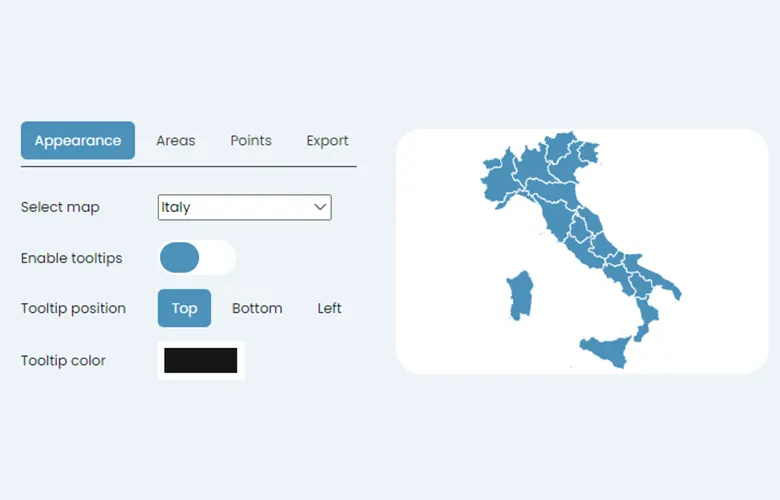
It offers an exceptional toolkit for those seeking engagement with digital mapping and geographic visualizations. The centerpiece of this plan is the Interactive Map Editor, a powerful feature that allows users to create and customize maps with pinpoint accuracy. This editor not only provides customizable colors and tooltips for over 230 interactive countries but also gives users the ability to add custom points of interest and embed these maps directly into websites. This is particularly beneficial for developers, educators, and marketers who are looking to present geographical data in a more dynamic and interactive manner.
In addition to the map editor, the Plan includes access to an extensive collection of 230+ country flags, presented in high-definition, vector, and image files. These flags are available in multiple formats including PNG, SVG, and JPG, with options for both flat and round corners, ensuring pixel-perfect images for any project.
Furthermore, subscribers gain access to high-definition country maps, with 7 types of maps available for each country. These maps are offered in vector and image file formats, also in multiple formats like PNG, SVG, and JPG, guaranteeing the highest quality visual representations for downloads.
By subscribing to the Premium Plan, users not only get these advanced tools and resources but also obtain a commercial license to employ these flags, maps, interactive tools, and graphics in a wide range of applications. This comprehensive access empowers users to harness the full potential of WorldMapHD, making it an indispensable tool for anyone involved in the creation, teaching, or utilization of geographic information systems.
About Interactive WorldMap HD
What’s Included in the Plan?
Subscribing to the Plan on WorldMapHD catapults your geographic visualization capabilities to unparalleled heights. This comprehensive package has been meticulously designed to serve a wide range of professionals, from developers and educators to marketers, who require precise and dynamic presentation of geographical data.
Interactive Map Editor:
Customizable Colors and Tooltips: Tailor the appearance of your maps with an array of colors, ensuring each section communicates effectively and aligns with your presentation or brand’s aesthetic.
230+ Interactive Countries: Gain access to an extensive library of countries, making it simple to create detailed and specific maps for any region of the world.
Add Custom Points of Interest: This feature allows you to pinpoint exact locations on your maps, enhancing the interactive experience for users and providing precise information.
Embed Maps in Your Websites: Seamlessly integrate interactive maps into digital platforms, enhancing user engagement and comprehension of geographical data.
230+ Country Flags:
High Definition Country Flags: Presenting flags in crisp, clear quality that captures the essence and details of each nation’s symbol.
Vectors and Image Files: Ensures flexibility in use across various platforms, whether digital or print, maintaining quality across all mediums.
Multiple Formats: With PNG, SVG, and JPG options, and the choice between flat and round corners, these flags are designed to meet a wide array of design needs, ensuring pixel-perfect images in every download.
230+ Country Maps:
High Definition Country Maps: Offering detailed maps that bring geographical details to life, facilitating a deeper understanding and appreciation of each country’s topography.
7 Types of Maps for Each Country: Cater to different informational needs, from political boundaries to physical terrain, providing comprehensive coverage.
Vector and Image Files: Like the country flags, these maps are available in multiple formats, ensuring that they are perfect for your intended use, whether it be in academic presentations, marketing materials, or digital applications.
Comprehensive Access with a Commercial License:
This license empowers you to employ WorldMapHD’s flags, maps, interactive tools, and graphics across a variety of applications and projects. It’s a game-changer for anyone involved in the creation, teaching, or application of geographic information, essentially making WorldMapHD an indispensable tool kit in the realm of geographic visualizations.
In conclusion, WorldMapHD’s Plan is not just a collection of tools and resources; it is a gateway to transforming the way geographical data is presented and understood. Whether for educational purposes, marketing campaigns, or software development, the Plan offers the versatility and depth needed to address a wide range of geographic informational needs.
What are the Pros and Cons of Interactive WorldMap HD
Pros
- Enhanced Engagement with Geographical Data: The Interactive Map Editor significantly elevates the ability to engage with and present geographic information, allowing for a more dynamic and enriched user experience.
- Comprehensive Toolkit: With access to over 230 high-definition country flags, detailed maps for each country, and customizable interactive maps, users are equipped with a vast array of tools to meet their specific needs.
- Versatility in Formats: Offering multiple file formats, including vector and image files in PNG, SVG, and JPG, ensures that the graphics are compatible across various platforms, preserving their quality.
- Commercial License Included: Subscribers gain the freedom to utilize these resources across a broad spectrum of applications, greatly enhancing the value of their projects or presentations.
- Supports a Wide Range of Professionals: Whether you’re a developer, educator, or marketer, the Premium Plan caters to a diverse audience requiring precise and engaging presentation of geographical data.
Cons
- Cost Barrier for Some Users: The subscription model might represent a financial constraint for individuals or smaller organizations with limited budgets.
- Possible Learning Curve: New users may face a learning curve in mastering the Interactive Map Editor and utilizing the full suite of tools available effectively.
- Internet Dependency: Accessing and using the platform’s features requires a stable internet connection, which could be limiting in areas with poor connectivity.
- Risk of Overwhelming Options: With such an extensive collection of tools and features, some users might feel overwhelmed by the options available, potentially complicating their workflow.
- Niche Focus: While incredibly valuable for those working directly with geographical information systems, the platform’s focus may not cater to professionals outside of these areas, limiting its universal appeal
How does Interactive WorldMap HD Work?
WorldMapHD works on operating geographic visualization technology, combining user-friendly interfaces with sophisticated mapping tools. At the bottom of its functionality is the Interactive Map Editor, a versatile platform allowing users to create, customize, and embed interactive maps into websites or presentations with exceptional precision. Users start by selecting the geographical region of interest, then proceed to customize various elements such as colors, tooltips, and add custom points of interest, thus creating maps tailored to specific needs and objectives.
In addition to map creation, subscribers have access to an extensive library of over 230 high-definition country flags and maps, available in various formats for both web and print use. This comprehensive toolkit, complemented by a commercial license, allows professionals from diverse fields to leverage the full potential of digital cartography, making WorldMapHD an indispensable resource for anyone looking to enhance their engagement with geographic data.
Customer Reviews
After subscribing to the Premium Plan, Dan J.Shaw discovered a treasure trove of resources that transformed his approach to project visualization. He was particularly impressed by the Interactive Map Editor, which allowed him to tailor colors, add detailed tooltips, and embed highly interactive maps directly into their project websites. This feature alone vastly improved the engagement and aesthetic quality of their digital content. The access to over 230 interactive countries enabled John to pinpoint custom points of interest, making his work feel even more tailored and impactful.

Conclusion
WorldMapHD operates by leveraging geographic visualization technology, blending user-intuitive interfaces with advanced mapping capabilities. Central to its functionality is the Interactive Map Editor, a sophisticated yet user-friendly tool that enables users to create, customize, and seamlessly embed interactive maps into websites or presentations. The process is straightforward and tailored to ensure accessibility even for those with minimal technical background. Users begin by selecting their desired geographical region, after which they can customize various map elements — such as colors, tooltips, and the addition of custom points of interest — to create maps that meet their specific requirements and objectives accurately.
Once a map is designed to satisfaction, the embedding feature facilitates its integration into digital platforms, thereby enhancing the delivery and comprehension of geographical data, whether for educational purposes, marketing strategies, or application development projects. This intuitive design process ensures that users of all skill levels can produce professional-grade geographic visualizations with relative ease.
Frequently Asked Questions (FAQs)
Q. Can I use the Interactive Map Editor without any prior experience in digital mapping?
Q. Are the maps and flags up-to-date with current geopolitical boundaries and designs?
Q. Can I integrate the maps created with WorldMapHD into any website or digital platform?
Q. What type of support does WorldMapHD offer to its subscribers?
Q. How secure is WorldMapHD’s platform? Are my projects protected?
Q. Is it possible to collaborate on map projects with team members using WorldMapHD?
Q. Do I need a constant internet connection to use WorldMapHD?
Q. Can I export maps and flags in formats other than PNG, SVG, and JPG?
Q. If I cancel my subscription, can I still use the maps and flags I’ve created?
Q. Are there any tutorials available to help me get started with WorldMapHD?
Where to Buy?
For more details, please click here
Fantastic Tool for Geographic Visualization!
I’m thoroughly impressed with Interactive WorldMap HD! It has transformed the way I visualize and present geographical data, thanks to its user-friendly interface and comprehensive toolkit. The high-definition maps and customizable features have made it an indispensable resource for my projects. Highly recommend for anyone in need of reliable and dynamic mapping solutions!